
SURVEYING IS EASY WITH US
serving Mississippi and Tennessee since 1999
Our team is equipped to survey your land!
Our field crew is equipped with the latest equipment available:
- Laptop computers
- Windows-based data collection
- Conventional total stations
- Robotic total stations
- Static GPS systems
- RTK GPS systems
- RTK GPS systems are capable of millimeter accuracy in elevation
EXPECT QUALITY CUSTOMER CARE
Professional
With our years of experience, we have specialized our skills and services to give you quality results. Work with the experts and receive nothing but the best.
Dependable
Want to get accurate and thorough surveying solutions? With our advanced technology, we have the tools to give you maps, boundaries, and more.
Friendly support
Our team is available to make sure that things run smoothly. We’re here to help you. Receive clear communication throughout the surveying process.
now offering construction surveying
We are excited to announce our pristine construction surveying service. Our experienced team will provide detailed and accurate surveys to ensure that construction projects are carried out with precision and efficiency. We offer various construction surveying services, including site analysis, grading, and stakeout to contractors, engineers, and architects. Our modern equipment and advanced technology ensure that we deliver quality results in a timely manner. Trust Sullivan Surveying, Inc. as your partner in construction surveying, and be confident that your project is in good hands.
UTILIZE OUR TOPOGRAPHIC SURVEYING
Our topographic surveying service is essential for land development projects and environmental analysis. With this service, our skilled professionals can accurately map and measure the physical features and natural characteristics of the land, including contours, elevations, and vegetation. This data is used to create detailed, 3D topographic maps used for planning and design purposes. Whether you're planning a new construction project or need to understand the lay of the land for environmental conservation purposes, our topographic surveying service is an indispensable tool for comprehensive land analysis.
Quality boundary surveying
Sullivan Surveying, Inc. offers accurate boundary surveying services to residential and commercial clients. Our boundary surveying service involves identifying and marking the boundary lines of a property. It is important to avoid any disputes with neighboring properties or encroachments on your land. We use the latest technology and equipment to conduct the survey and provide a detailed report that includes maps and drawings. Our team of experienced and licensed surveyors ensures that you receive a thorough and reliable survey. Trust Sullivan Surveying, Inc. for all of your boundary surveying needs.
reliebale route surveying services for infrastructure
Our comprehensive route surveys are ideal for infrastructure projects including roads, highways, pipelines, and transmission lines. Using advanced technology such as GPS and Total Station, we accurately map out and locate all critical features within the route corridor. Our survey reports are delivered in a timely manner and provide detailed descriptions, drawings, and recommendations for further action. Contact us today for your route surveying needs and let us assist you in building a foundation for your project.
Pristine laser surveying
Sullivan Surveying, Inc. is proud to offer our Pristine Laser Surveying service, which utilizes cutting-edge technology to provide the most accurate and precise land surveys possible. Using high-powered lasers to measure distances and angles, our surveyors can create detailed maps and plans with incredible speed and accuracy. Whether you're in need of boundary surveys, topographic mapping, or construction staking, our Pristine Laser Surveying service is the perfect solution for any project. Trust Sullivan Surveying, Inc. to provide the most comprehensive and reliable land surveying services available.
lidar mapping services
We are proud to offer advanced LiDAR mapping services, providing highly accurate and detailed topographic data for large-scale land surveying projects. LiDAR technology enables us to quickly and efficiently collect comprehensive data on terrain, vegetation, and obstacles, resulting in highly accurate and detailed topographic maps. Our LiDAR mapping services are ideal for a range of projects, including transportation infrastructure planning, land development, and natural resource management. Trust our experienced team to deliver the precise, reliable data you need for your next surveying project.
commercial aerial surveying
Sullivan Surveying, Inc. offers a top-tier commercial aerial surveying service that provides accurate and detailed survey data to a variety of industries. By utilizing state-of-the-art drone technology, our team can capture high-resolution imagery and 3D models of large or hard-to-reach areas, streamlining the surveying process and reducing the need for time-consuming manual measurements. Our aerial surveying service is ideal for construction projects, real estate development, and environmental assessments, and our experienced team ensures that all data collected is reliable, efficient, and adaptable to any project requirement.
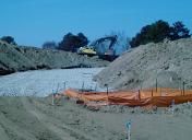
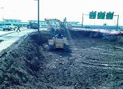
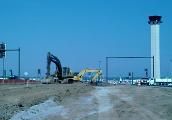
OUR PROJECTS
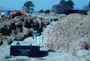
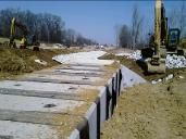
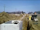
Gallery of the drainage, roadway, and parking areas during construction of the Inbound Roadway at Memphis International Airport
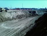
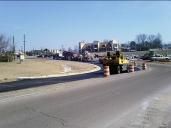
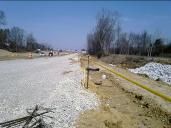
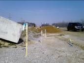
Gallery of curb stakes, drainage, and the roadway during construction of Missisippi Highway 305.
Get Connected Today
Please reach out to us with your inquiries. We look forward to hearing from you!
6111 MS-4 W, Ripley, MS 38663, United States of America
Contact Us
Frequently Asked Questions
See some common questions and answers below, or call us at 662-837-8553.
Land Surveying

CONTACT US
LOCATION
6111 MS-4 W, Ripley, MS 38663, United States of America